Location GPS Product Page
We are very pleased to introduce our new product, the Test Location GPS. This GPS is a software system that provides an easy and efficient way to map GPS coordinates of construction site test locations. It can also create professional reports of the tests. In other terms, the Test Location GPS allows you to enter, import, or convert GPS coordinates for multiple tests, then compile a “test list” before mapping and reporting your list of tests.
GPS Instructions
Step 1. There are three ways to add test coordinates to the Test List:
1) Enter each test coordinate manually in any GPS format. Select [Convert], and the program will convert this to Latitude/Longitude format and add the test to the list.
2) Add the test coordinates to the Excel Template, then import the template to the Test List.
3) Import a standard .GPX formatted file (Including waypoint.gpx files from Garmin handheld GPS sensors).
Step 2. Add the test coordinates to the Excel Template, then import the template to the test list.
Step 3. Report the list to a PDF file.
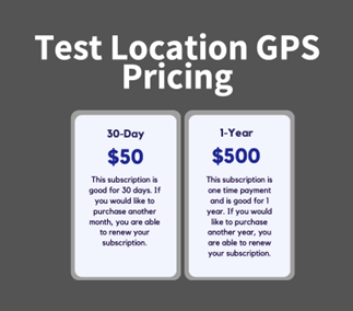
Note: This GPS page is loaded as a “Demo” with limited functionality. For full functionality including professional reports, 30 day or 1 year subscriptions may be purchased.